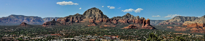
The Memorial Day crowds have left Sedona and we like it a whole lot better. We didn’t emerge from our room until 11 am and took a walk (not quite able to call it a hike) amid the red rocks. Then we had a long lunch outside and did some shopping. The rest of the day has been blessedly taken up with reading and writing.
Photos of walk (placeholder)
One of the reasons we are so diligent in writing this blog is that if we don’t we tend to forgot pretty quickly what we have done and where we have been. It serves to jog our memories and hopefully at the same time offer some information and entertainment for others. We’ve been on the road for 4 weeks and it’s time to push in the proverbial clutch and just coast for a bit. To start we took an entire day to travel back up to Sedona for some R&R. We stopped along the way at Montezuma's Castle National Monument and at the town of Jerome AZ. Montezuma's Castle National Monument
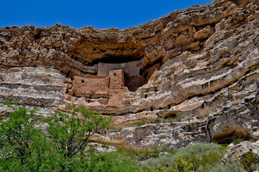 Montezuma's Castle is not a castle and it had nothing to do with Montezuma. The structures are cliff dwelling built by the Sinagua people about 700 A.D. When the dwellings were “discovered” in the 1860’s they were mistaken attributed to the Aztec emperor Montezuma. Montezuma it turns out was born 100 years after the dwellings had been abandoned by the Sinagua Although certainly dramatic the 50-room cliff dwelling at Montezuma’s Castle is not large in comparison to Mesa Verde or even the 100-room pueblo ruins at Wupatki. Maybe our experience was jaded by the hoards of folks who decided to make this site a stop on their Memorial Day weekend excursion. Given that we typical travel in the “low seasons” we frequently find ourselves alone at the smaller sites. This was not the case today. Or maybe it was because of the timeline display in the visitor’s center. It contrasted what was happening in other locations to the events at Montezuma’s Castle. I let out an audible gasp when I arrived at the panel illustrating 1775 and the copy indicated that the First battle of the American Revolution happened at Concord, MA. Those around me were, of course, interested in the reason for my outburst and I took the opportunity to inform them of the error and invited them all to visit the place where the American Revolution actually did begin. Since the ranger’s didn’t seem perturbed by their error I made sure to fill out a comment card. Do not fear my fellow history buffs back home – I’m doing my best to rid ill informed of their misconceptions regarding exactly where that “First Shot” occurred.
Photos of Montezuma's Castle National Monument (placeholder) Jerome AZ
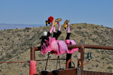 Three Ladies we saw in Jerome Jerome AZ has many claims to fame. “America’s most Vertical City: “Largest Ghost Town in America” “The Almost Mile High Town” (80 feet short of that distinction) After it’s founding in the late 1800’s it was a copper mining town. It’s population peaked in 1920 when 15,000 hardy souls lived up and down the hillsides. By 1950 it was a ghost town and the few remaining residents promoted it as such. Then came the artists, musicians, authors who are always followed by the shopkeepers, restaurateurs and real estate developers and voila you have a destination town. All in all its a pleasant place to spend the afternoon.
Photos of Jerome AZ (placeholder)
White House Inn, Sedona We’ve settled into the White House Inn a bit away from the main action. It is a small 20 room facility. The hands on owner who shortens his Indian (not native American) name to Hersh is a delight. The room is large clean, with a balcony with a view of some of those red rock formations. The fridge and microwave mean we can lay off restaurant food for the week. Best of all it is affordable in a town where most of the names of the lodging ends in "... Resort".
Taliesin West
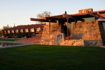 A placeholder image until I get one of Ben's photos of Taliesin West Fifteen years ago, Harry managed to tour Frank Lloyd Wright’s Taliesin West while in Arizona on a business trip. On the way to the airport this morning Harry took Ben on a detour to drive by Taliesin for a photo op.
When we entered the reception area, a lady asked me if we were here for a tour. I replied that because Ben had to catch a plane, we really didn’t have time for a tour. A very nice man overheard my response, and said, “Hey, I’ll give you a quick tour”. Wow, this was great. He gave us a tour through the building, giving Ben a good feeling for the place. What a nice guy. I told him we would be back next week with our other son Will.
Heard Museum 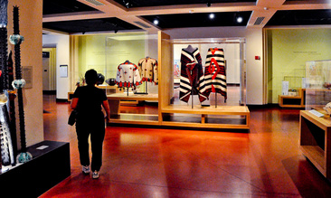 A beautiful exhibit titled "Home" in the Heard Museum After Ben was securely on his way back to Boston, we went into Phoenix. The Heard Museum in downtown Phoenix presents Native arts and cultures. We took the offered introductory tour which was lead by two young men. One was of Hopi heritage, the other Navajo and they did a wonderfuljob of explaining the art of their people. One highlight for us was the impressive Katsina (their interpretative spelling for the more common Katchina) collection. There are ancient works as well as contemporary examples. The outdoor courtyards are filled with sculpture. We had our lunch in the shaded courtyard with its bubbling fountains.
Photos from Heard Museum (placeholder) This afternoon we took some time to write, read, and generally recover from a delightfully busy week with Ben. It was a pleasure to have him with us.
 A Common Scene in Sedona Ben planned a more relaxing day for us today. His day would include some real hiking while ours included some time to just sit and enjoy the scene as well as walking on more level terrain. He began with a hike into an area called Devil’s Bridge.
We headed for downtown Sedona and a leisurely cup of coffee while watching the passing scene. When we picked him up a few hours later he was covered in red rock dust and thirsty but quite happy.
Photos of Ben's Hike to Devil's Bridge (placeholder) Red Rocks State Park, Sedona Airport and Bell Rock We had a picnic lunch at Red Rocks State Park and drove their loop road then drove up the airport road (the airport is on top of a mesa) and took in the overall view of the entire scene.
Photos from the Airport Mesa (placeholder) There was a bit of shopping and general touring (read, We had an ice cream cone...) and then the afternoon hike/walk at Bell Rock. Ben climbed 3/4s of the way up the rock while we strolled around the base as the sun was setting.
Photos of Ben's Bell Rock Climb (placeholder) While Ben climbed Bell Rock, we took the flatter trail that went around Bell Rock. On our return, we all spotted a rather spectacular fire of an RV Camper on the highway. Here are photos and videos of the fire
Photos of RV Camper fire (placeholder) Then we drove the 2 hours to Scottsdale to be in position to take Ben to the airport in Phoenix on Sunday morning.
It’s a beautiful place. We will be returning on Monday to stay for 5 days.
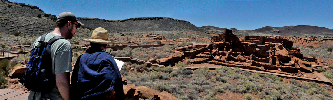
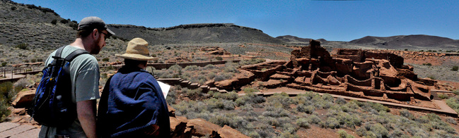 Ben and Marsha read about Wupaki ruins Given Ben’s limited amount of time he wants to see and do as much as possible. We are willing to indulge him but wondered if we could actually accomplish our goal for today which was to visit and enjoy three National Monuments in one day. We had planned to go to Wupatki National Monument and Sunset Crater National Monument but Brantley Baird (see Thurs. May 26th) convinced us we needed to also go to Walnut Canyon National Monument. We were glad we did but it made for a VERY LONG day. Walnut Canyon National Monument is on the outskirts of Flagstaff, Arizona. We arrived with the first wave of morning visitors and began our 180-foot descent (thats 240 steps) into the canyon to view the cliff dwellings on the Island Trail. The “island” is a promontory that juts out into the canyon. There are 25 cliff dwellings along the trail and many others visible across the canyon. There is the added attraction of excellent markers pointing out and explaining the plant life along the trail. Since I was wearing a red shirt I also enjoyed the added benefit of being dived bombed by the hummingbirds that mistook me for a giant red flower. Another hour and several climate zones later we were at Wupatki National Monument. Wupatki means Tall House in the Hopi language. Occupation of this site began in the late 1100’s. There are the ruins of the 100-room pueblo, a ceremonial room and a ball court. There were probably 2000 people living in the area. Near the ball court there is a geological blow hole. According to Wikipedia:
"A blowhole is also the name of a rare geologic feature in which air is either blown out or sucked into a small hole at the surface due to pressure differences between a closed underground cavern system and the surface. The blowholes of Wupatki National Monument are an example of such a phenomenon. It is estimated that the closed underground passages have a volume of at least seven billion cubic feet. Wind speeds can approach 30 miles per hour. Despite the relief offered by the blowhole it was brutally hot during our visit there so we did not linger. Sunset Crater National Monument. The volcano erupted in the 11thcentury and blanketed the area (including Wupatki) with volcanic ash. At this National Monument you view the crater from afar and view areas that still graphically show the results of the eruption. Since we were not yet totally exhausted and because Ben wanted to see a bit of Flagstaff itself we headed to Heritage Square. Harry and I found a bench to view the scene and Ben took the more active approach of walking around the nearby streets. Then we piled back into the car and drove the spectacular Oak Creek Canyon road (Route 89A) from Flagstaff to Sedona. Arriving by providence in Sedona at the “magic hour” to photograph the Red Rocks. I could barely hold myself erect to eat dinner. It had been a long day but we were all in good spirits and our minds and cameras filled with glorious images. Plus I had three new place stamps in my National Park Passport.
Rock Art Canyon Ranch
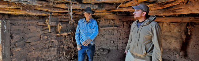 Brantley Baird explains the Anasazi hogan structure to Ben Harry's friend Steve Cohn recommended that we check out a place near Winslow called Rock Art Canyon Ranch. We knew we had stumbled onto to something interesting after checking reviews on Trip Advisor but were definitely convinced after talking to the owner Brantley Baird on the phone. Brantley sounds like and is a real cowboy. Brantley's family bought the ranch in the mid-1940's when he was about 10. He grew up on the ranch, which is about 25 miles outside of Winslow. The last 15 miles are dirt road. As a teenager he found his first Anasazi pot just sticking up out of the dirt. He was hooked. Now he has an amazing collection of native artifacts along with a staggering collection of old farm and ranch equipment and cowboy memorabilia. But the real attraction here is Brantley himself. He’s a real character who has a million stories and irresistible charm and yet clearly has great reverence for the people who once lived on this land.
But the adventure had merely started. He and Ben hopped into his 4-wheel drive vehicle and we gingerly followed in our van. At one point he slowed down and gestured toward the Golden Eagle flying in circles overhead. Then more dusty one lane roads through the range land and we stopped to see Anasazi ruins and a Navajo Hogan. As we walked toward the ruins there were shards of Anasazi Pottery scattered around with the familiar white and black designs.
More dusty roads and we arrived at the top attraction at the ranch -- The Canyon. After an overview from the observation platform he had had constructed he left us to explore the canyon on our own. We gingerly descended to the Canyon floor and were rewarded for the effort by the thousands of Petroglyphs on the Canyon walls. We wandered about, taking in the scene and taking lots of pictures. Then perched on rocks took off our shoes and socks and soaked out feet in the cool stream.
Here is an instance of how a private citizen can preserve, protect and find a way to share it with those who also appreciate it.
Photos from Rock Art Canyon Ranch (placeholder) Meteor Crater
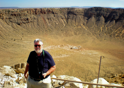 Notice right hand holding on to railing: the wind was blowing 60 miles an hour ! Meteor Crater is one of those places where eventhough there isn't much to see, but you've got to see it anyway. It is, afterall, a big hole in the ground -- it's what you would expect if you tossed a ball into wet sand, only the ball is pretty big, and traveling pretty fast -- so fast, that it self distructs when it hits the ground and send the contents of a 3/4 mile hole in all directions.
Also, one of the coolest things about Meteor Crater is this is exactly what those craters we stare at on the Moon are like -- except a lot smaller. There was a display showing the relative size of this crater to those on the moon -- and this was a lot smaller, yet it was very big.
Two years ago this summer, my friend Rick Beyer went and filmed a documentary about the Tunguska "cosmic event" that happened in Siberia in the early 1900s. There is no such crater for the Tunguska meteor probably because it exploded prior to reaching the earth. It did flatten the trees
Photos from Meteor Crater (placeholder)
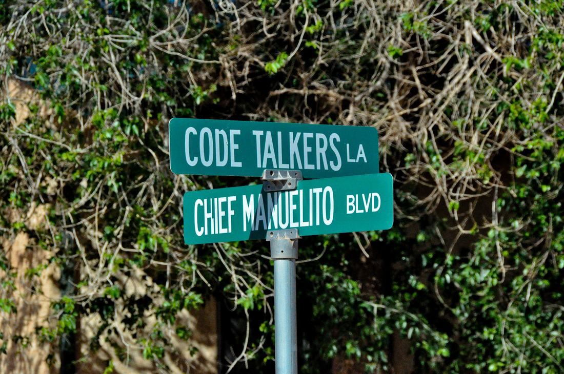
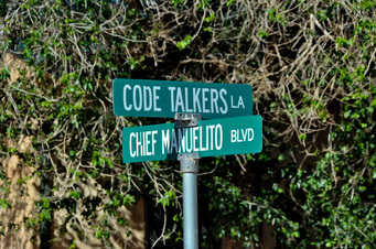 Intersection behind the Chinle Hospital Before we left Chinle this morning we went in search of the Hospital facility. Marsha’s nephew Andrew and his family will be living in Chinle for the next two years while he works at the Department of Interior staffed Hospital. The hospital is off the main road and is surrounded by housing for the staff. It will certainly be an interesting place to be. The intersection pictured to the right references the Navajo Code Talkers, Navajo soldiers who contributed a vital service during World War II of providing an intrinsically secure communication channel: speaking in a language that no one else in the world spoke.
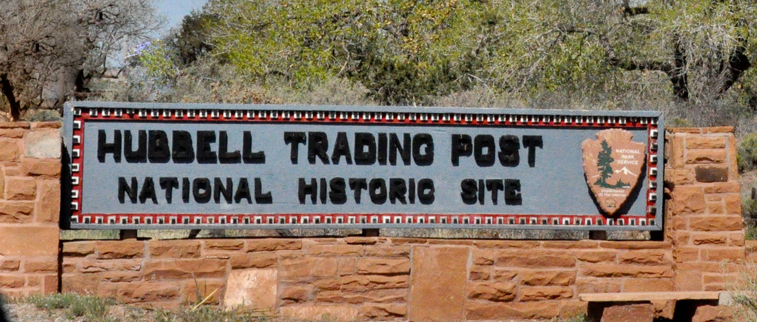
Photos of Chinle Hospital Area (placeholder) Hubbell Trading Post National Historic Site  An hour after leaving Chinle we were at the Hubbell Trading Post National Historic Site. See also Wikipedia. In 1878 John Lorenzo Hubbell purchased this trading post. Family members operated the trading post until it was sold to the National Park Service in 1965. We were disappointed that the trading post itself has not be restored to its original state but rather is operated as a store by the Western National Parks Association. It does, however, retain some of the original features. The real charm of the place is in Hubbell’s 160-acre homestead that was left in its original state. The gem here is the house itself. The ceiling of the central hall is covered with the Indian baskets that Hubbell collected. The walls are covered with the hundreds of the paintings and sketches done by visiting artists who willingly gave their work to Hubbell in thanks for his hospitality. Everywhere you look there are Navajo rugs. Used as blankers, floor, sofa and table coverings. The décor in its entirety elicits a gasp as you enter. Once you adjust you notice the details. The beaded Indian saddlebags placed above the doorways. The dining room table made to order in Cincinnati. Hubbell purchased the table with the profits from sheep’s wool and so asked that the corners of the table and the design on the sideboard include carved rams heads. The National Park Service has a nice website devoted to the art in the Hubbel Traiding Post titled Navajo Portraits.
Photos of Hubbell Trading Post (placeholder) Art and Crafts at the Hubbell Trading Post There were many different pieces of art throughout the Hubbell Trading Post as well as in the Hubbell family home: paintings, Navajo rugs and blankets, baskets, trays, jewelry. This is a very place to visit if you are interested in American Indian Arts and Crafts. Paintings at the Hubbell Trading Post Navajo Rugs There were several rooms devoted to Navajo Rugs. It was breathtaking to see so many authentic rugs in one place. When Hubbell began trading the Navajo were weaving blankets. These square blankets were used for bedding and worn as a shawl like garment. Hubbell convinced them to weave in rectangular shapes and began selling the Navajo weavings as rugs. His other major contribution to the Navajo rug trade was inadvertent. He loved the color red. The Navajo traditionally used muted tones of grays, browns, and creams. In order to please Hubbell and sell him more rugs they started adding a bit of red and subsequently more and more. Rugs and Blankets used for a variety of purposes Patterns for Navajo Rugs I'm only guessing at this explanation, but I'm going to guess that Navajo rugs were ordered based on a painting of the rug. Below are 20 or so patterns that were offered. There were more. Each of these was an 8"x10" drawing of a rug you could order Hopi Mesas  The Hopi do not allow photographs to be taken. Ugh... We left Hubble and drove for an hour to the Hopi Mesas. The treatment of the Native populations by the settlers and U.S. Government was and continues to be deplorable. The Hopi were perhaps dealt the worst hand. Their reservation is on god-forsaken land. The three stone mesas rising above the arid plains. The lands of their sworn enemies the Navajo surround the Hopi reservation. Their remote location far from any major population center precludes the possibility of building a casino that would generate funding. Many Hopi remain in poverty with their beliefs and traditions intact.
They put very little effort into presenting their culture and arts to outsiders.
All of the other Indian Cultural centers that we had visited did an excellent job of presenting their history, culture and art. The Hopi Cultural Center was just depressing. There was little or no information on how to see their villages. Somehow we managed to forge ahead and try to keep a blind eye to the squalor around us. On first mesa we followed the hand written signs to a building were we purchased tickets for a lecture on the Hopi and a walking tour through two villages.
The tour guide in me tried very hard not to keep a running list of all of the “worst practices” of the lecturer/guide and just tried to take in the information. It was difficult. The reward at the end was the walk through the village of Walpi. The village is no longer inhabited full time but continues to be used to celebrations.
Walpi is at the very end of Mesa. Its stone and adobe buildings cling to the rock and hover precariously close to the edges of the cliffs. It is a spectacular setting.
Photos of area around Hopi Reservation (placeholder) La Posada Hotel 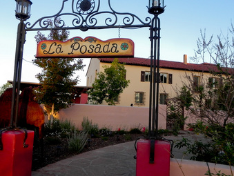 Another hour’s drive and we were in Winslow, Arizona which has two claims to fame. Remember that Eagles Song “Take it Easy” and the line about “Standin on the Corner in Winslow, Arizona”. These days there is statue of a young man with a guitar standing next to a lamppost on that corner and visitors, like us, can stand there like the aging children of the 60’s we are and have their picture taken.
La Posada Hotel was built in the late 1920’s as the last of the great railway hotels built by the Santa Fe Railroad. The hotel was designed by Mary Jane Colter who was the architect responsible for that distinctive melding of arts and crafts and western styles known as park-a-tecture. The Fred Harvey Company ran the hotel. Every train of the time that went between Los Angeles and Chicago stopped at La Posada.
After being closed for 40 years the Hotel underwent restoration in 1997 and is now again a vibrant hotel. We are staying at the local Quality Inn but went to La Posada last night for dinner. Its restaurant, the Turquoise Room, is considered to be the best restaurant in the four corners region. It lived up to its reputation. We had a wonderful elegant and tasty dinner after which we walked around the public rooms of the hotel. The new owners have added contemporary art to the mix and the effect is stunning.
If you find yourselves in Winslow do by all means stay at La Posada and have your photo taken on that particular corner along the “Mother Road”, Route 66.
Photos of La Posada (placeholder)
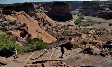 After a quick visit to the National Monument Visitors Center we drove to the White House Ruins overlook and began walking the trail descending into the canyon to view the ruins. Like all good National Park Service trails that deal with elevation this one snaked down the side of the cliffs to the canyon floor. I (Marsha) was feeling the heat and elevation a bit and made it down three quarters of the way and then turned to walk slowly back up.
Ben and Harry successfully made it to the bottom, viewed the White House Ruins and returned to the canyon rim. Harry says: The trip down was pretty easy, save for my tired knees. Once we got to the bottom of the Canyon wall, the trail went through a pretty area with a small one room house and then went along a dried up riverbed until we got to the White House Ruins. There was a group of college geology students on a field trip writing down their observations -- plus a handful of Indian vendors selling their crafts.
This was our first view of ruins this trip and it was impressive. In general, although none of the ruins in Canyon de Chelly are as massive as in Mesa Verde, there are a lot of separate locations where there are cliff dwellings here. The pictures speak better than my uneducated words on this subject.
Photos of White House Ruins (placeholder) After lunch we met up with our guide Ben from Antelope House Tours. This particular tour company had come highly recommended so we were psyched. We were not disappointed. We were the only ones on this three-hour tour. (Again the benefits of travelling before the season begins.) Ben (who is the father of the tour company owner) was born in the canyon and has lived there all his life. We were able to visit his current family compound nestled next to the Antelope House Ruins where his daughter made us fresh Navajo fry bread. Ben is a man of few words but the canyon tends to speak for itself and he did answer all our questions succinctly. Towering red sandstone cliffs rise from the canyon floor, which is verdant green with Cottonwoods and Willow. The four wheel drive vehicle sloshed through shallow water, jerked and shook while successfully fording deeper and faster flowing water and took us amazing close to Anazazi House Ruins, Caves, and Petroglyphs. An amazing afternoon.
Photos of Antelope House Tour (placeholder)
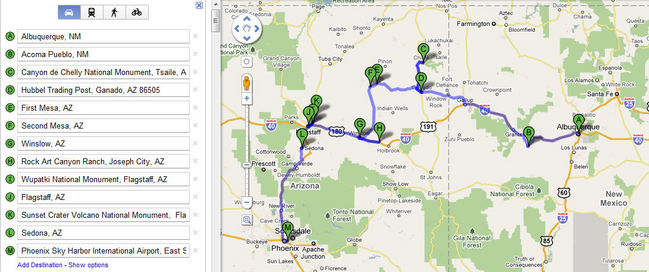
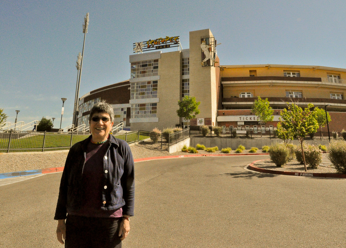
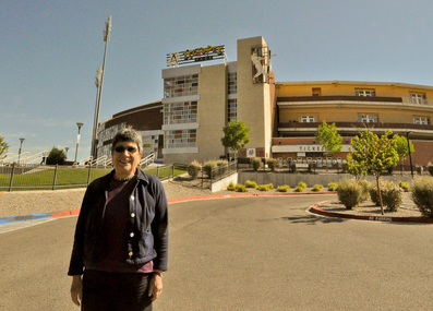 Marsha in front of Albuquerque Isotopes Pacific Coast League Baseball Stadium We have a tradition in our family of visiting stadiums [sic] in cities we visit. This is to honor the interest Will has in all things sports. When Will isn't around one of us (usually Marsha) steps in to fill his shoes. The Albuquerque Isotopes got it's name from the team with the same name from the Simpsons. To quote Wikipedia: "The fictional Springfield Isotopes from the long running TV series The Simpsons were the influence for the new name of the team. In the episode " Hungry, Hungry Homer", main character Homer Simpson attempts to thwart the team's plan to move to Albuquerque by going on a hunger strike. Subsequently, when an Albuquerque Tribune online survey helped the team decide its new name, "Isotopes" received 67 percent of the 120,000 votes. ... The "Isotopes" name is appropriate, since New Mexico has a number of well-known scientific/military facilities dealing with nuclear technology, such as Los Alamos National Laboratory, Sandia National Laboratories, and the Waste Isolation Pilot Project (WIPP), as well as hosting the Trinity test." Last night at dinner, we talked over what we could do this week. Here's the planned itinerary that we came up with http://goo.gl/maps/4y2P
 Click to see larger image On a previous tour to New Mexico we arrived at Acoma Pueblo too late in the day to take a tour so this time around we decided to take no chances and go early in the day. Since Acoma has been continuously occupied since 1150 A.D. it is the oldest community in North America. Yes that is 861 years and counting. For defensive purposes the Pueblo was built atop a 367-foot sandstone bluff. The young Acoma man who was our guide told us the history of his people and this place with a deft combination of seriousness and humor. In 1629 the Spanish priest and soldiers occupying the town forced the Acoma to build the Mission of San Esteban del Rey on the land that had been their sacred plaza. The walls of the mission are two feet thick. The ponderosa pine roof beams were carried by hand from the mountains just visible off in the distance. The priest insisting that these poles destined for his church never touch the ground during their journey to Acoma. He was not a nice man.
After our tour of Acoma we began our drive through the Navajo reservation to Canyon de Chelly National Monument in Chinle, Arizona. We arrived in time to have an early dinner and drive the south rim drive 12 miles to the Spider Rock Overlook to view the late afternoon light and watch the sunset over the canyon. We were awed by the view and are looking forward to a full day here tomorrow.
Photos of Acoma Pueblo (placeholder)
 Both Marsha and Harry wrote accounts of this day. Here is Harry's description:We stayed around the hotel this morning, cleaning up the car and getting our act together. We seem to need to do this every week or so. At around noon we drove the short distance to the Albuquerque International Sunport (although I get the Sun part, not sure if I saw this in isolation, I would think it was an airport). Nice small airport. Great area to wait for incoming passengers: a parking strip where you can watch the airplanes land. Gives you something to do while waiting. Ben arrived right on time and we whisked him off to the Indian Pueblo Cultural Center for lunch. It was great to see him. We had a nice lunch in their cafe and then proceeded to see a very good demonstration of Indian dances. There was a troop of 3 dancers plus their leader who gave a pretty good description of what was going on. I say pretty good because at times I wished we would see more dancing and less talking, but I did learn some things that I didn't know before, so I guess his talking was a good idea. The Cultural Center has several different exhibits, include a permanent display of the artifacts of 19 different Pueblos in New Mexico. I found it interesting to see a group of artifacts from one Pueblo side by side with similar types of artifacts from other Pueblos. Comparing this with other museums devoted to Indian culture, this museum's strength was the comparative aspect of its displays. So far, I think the Indian Arts & Culture museum in Santa Fe was the best we have seen. After the Indian Pueblo Cultural Center, we took Ben over to Albuquerque Old Town to walk around and see what has now become a quaint place for tourists to buy souvenirs. The price of anything unique to take home in this area (as in most areas) of the country has gotten beyond our price range. I have gotten used to discovering that items that I think I would like to bring home turning out to cost hundreds of dollars, and more than my interest in the item would warrant I pay for it. We were all beginning to droop, and so we went back to the hotel for a rest. After that, we went to a great restaurant that Ben's friend Jeremy recommended -- Sadie's Dining Room. It was excellent and I would pass on Jeremy's recommendation. And, here is Marsha's description:While waiting for Ben to arrive at the Albuquerque airport today we were impressed by just how civilized it was. This relatively small airport has a cell phone waiting lot plus a spot to watch planes land and take off. Ben arrived on time and in good spirits. We whisked him away to the Indian Pueblo Cultural Center for lunch followed by Native dances in the courtyard. The 19 Pueblos that are represented therein run the museum so the dance demonstration was as informative as it was entertaining. Their permanent exhibition gave us an overview of the Pueblos as well as a good comparison of the artwork and crafts for each Pueblo. Since Ben had asked for advice of what to see in Albuquerque from his college roommate Jeremy who grew up here Ben called the shots of what we did the rest of the day. First up was a slow and casual walk around the Old Town and then dinner at Sadie’s an Albuquerque institution. The food lived up to its reputation for spiciness and for the size of the portions. There was plenty leftover for lunch tomorrow.
Photos of Indian Pueblo Cultural Center (placeholder)
|


 RSS Feed